
january 2005
BBC Science News
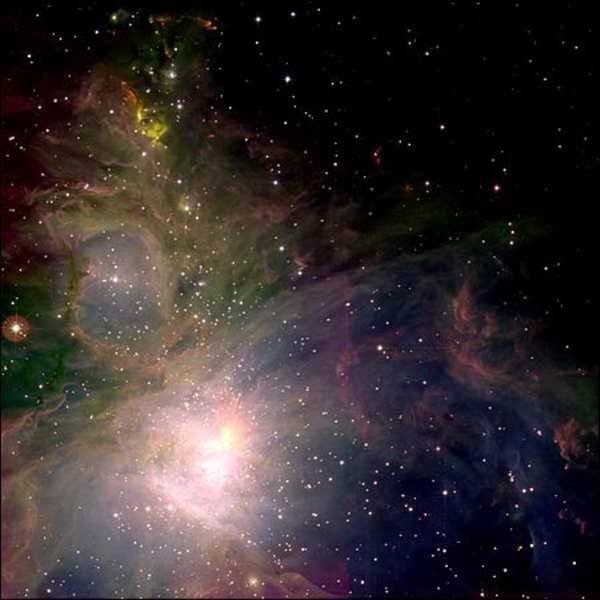
Astronomers have produced some amazing pictures using a remarkable new instrument on the United Kingdom Infrared Telescope in Hawaii.
The Wide Field Camera (WFCAM), built at the UK Astronomy Technology Centre in Edinburgh, is the world's most powerful infrared survey camera.
WFCAM was trained on a region of star formation in the Orion constellation about 1,500 light-years away.
The stunning images cover an area of sky that was unobtainable before.
"The ability to see such a large
area at once, with state-of-the-art detectors, makes
WFCAM the fastest infrared survey instrument in the
world, bar none," commented Dr Andy Adamson, head of
operations at the Hawaii telescope, which is sited on top
of the Mauna Kea mountain.
The World's Coldest Areas suffer a
Permafrost Melt
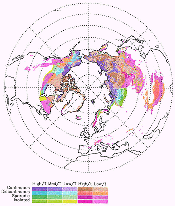
Distribution of permafrost and
ground ice in the Northern Hemisphere, based on the
EASE-Grid version of the IPA map. "High,"
"Med" and "Low" refer to ice content,
and "T" and "t" refer to thick and
thin overburden, respectively. Image courtesy of the
International Permafrost Association, supplied by Tingjun
Zhang, National Snow and Ice Data Center, University of
Colorado, Boulder.
| Exactly what
is permafrost? Permafrost is not defined by soil
moisture content, overlying snow cover, or
location; it's defined solely by temperature. Any
rock or soil remaining at or below 0° C for two
or more years is permafrost. Permafrost can
contain over 30 percent ice, or practically no
ice at all. It can be overlain by several meters
of snow, or little or no snow. Understanding
permafrost is not only important to civil
engineering and architecture, it's also a crucial
part of studying global change and protecting the
environment in cold regions. Determining the location and extent of permafrost is often difficult. The historical approach has been to assume that ground temperature equals the overlying air temperature, but ground and air temperatures usually differ, and by varying amounts. Even in areas where the mean annual air temperature is below freezing, permafrost may not exist. Land under glaciers, rivers, and streams is often free of permafrost despite freezing air temperatures at the surface (Williams and Smith 1989). Geologists and geocryologists have mapped permafrost for at least 50 years. In 1990, the International Permafrost Association (IPA) recognized the need for a single, unified map to summarize the distribution and properties of permafrost and ground ice in the Northern Hemisphere. The IPA map shows the distribution of permafrost and ground ice for the continental landmasses, areas of mountain and plateau permafrost, sub-sea and relict permafrost, relative abundance of ice wedges, massive ice bodies and pingos, and ranges of permafrost temperature and thickness (Brown et al. 1998). |
Alaska is not the only region in a slump. The permafrost melt is accelerating throughout the world's cold regions, scientists reported at the recent Fall Meeting of the American Geophysical Union (AGU) in San Francisco.
In addition to northern Alaska, the permafrost zone includes most other Arctic land, such as northern Canada and much of Siberia, as well as the higher reaches of mountainous regions such as the Alps and Tibet. All report permafrost thaw.
"It's a very, very widespread problem," said Frederick Nelson, a geographer at the University of Delaware, US.
Scientists attribute the thaw to climate warming. As the air temperature warms, so does the frozen ground beneath it. The observations reiterate the recent findings of the Arctic Climate Impact Assessment report, which attributed the northern polar region's summer sea-ice loss and permafrost thaw to dramatic warming over the past half-century. Thawing permafrost can cause buildings and roads to droop, and pipelines to crack. Natural features are also affected. Scientists reported an increased frequency in landslides in the soil-based permafrost of Canada, and an increased instability and slope failures in mountainous regions, such as the Alps, where ice is locked in bedrock.
With the exception of Russia and its long history of permafrost monitoring, global records are insufficient - often too brief or scattered - to determine the precise extent of ice loss, said Dr Nelson.
However, monitoring programmes that are now much larger in scope, such as the Global Terrestrial Network for Permafrost (GTNP), indicate a warming trend throughout the permafrost zone. Boreholes in Svalbard, Norway, for example, indicate that ground temperatures rose 0.4C over the past decade, four times faster than they did in the previous century, according to Charles Harris, a geologist at the University of Cardiff, UK, and a coordinator of Permafrost and Climate in Europe (Pace), which is contributing data to the GTNP.
The Earthquake
"All the planet is vibrating" from the quake,
said Enzo Boschi, the head of Italy's National Geophysics
Institute. Speaking on SKY TG24 TV, Boschi said the quake
even disturbed the Earth's rotation.
| Overview : As the Earth cooled from a gaseous ball, its interior formed several layers . The innermost layers, or core and lower mantle, do not directly generate volcanic eruptions. It is the outermost layers, or solid crust and asthenosphere, from which volcanoes form. According to the theory of plate tectonics, the Earth's crust is divided into large blocks or plates that slide around on the planet's outermost layer The theory has been almost universally accepted largely because it explains many geological events and patterns in a simple and unified way. The study of volcanoes also benefited significantly from this theory. Maps showing the boundaries of tectonic plates and volcanoes show that most volcanoes occur near the edges of tectonic plates |
The magnitude scale
is really comparing amplitudes of waves on a seismogram,
not the STRENGTH (energy) of the quakes. So, a magnitude
9.7 is 794 times bigger than a 6.8 quake as measured on
seismograms, but the 9.7 quake is about 23,000 times
STRONGER than the 6.8! Since it is really the energy or
strength that knocks down buildings, this is really the
more important comparison. This means that it would take
about 23,000 quakes of magnitude 6.8 to equal the energy
released by one magnitude 9.7 event. Here's how we get
that number:
One whole unit of magnitude represents approximately 32 times (actually 10**1.5 times) the energy, based on a long-standing empirical formula that says log(E) is proportional to 1.5M, where E is energy and M is magnitude. This means that a change of 0.1 in magnitude is about 1.4 times the energy release. Therefore, using the shortcut shown eartlier for the amplitude calculation, the energy is,
32 * 32 * 32 / 1.4 = 23,405 or about 23,000
The actual formula would be:
	((10**1.5)**9.7)/((10**1.5)**6.8)

	= 10**(1.5*(9.7-6.8)) = 10**(1.5*2.9) = 22,387
This explains why big quakes are so much more devastating than small ones. The amplitude ("size") differences are big enough, but the energy ("strength") differences are huge. The amplitude numbers are neater and a little easier to explain, which is why those are used more often in publications. But it's the energy that does the damage.
http://neic.usgs.gov/neis/eqlists/eqstats.html
| The dense mangrove
forests stood like a wall to save coastal
communities living behind them," said M.S.
Swaminathan, Chairman, M.S. Swaminathan Research
Foundation (MSSRF), Chennai. The mangroves in Pitchavaram and Muthupet region acted like a shield and bore the brunt of the tsunami. The impact was mitigated and lives and property of the communities inhabiting the region were saved. "When we started the foundation 14 years ago, we initiated the anticipatory research programme - a two-pronged strategy - to meet the eventualities of sea level rise due to global warming. One is to conserve and regenerate coastal mangroves along the eastern coast of the country, and the second is transfer of salt-tolerant genes from the mangroves to selected crops grown in the coastal regions. It is now found that wherever the mangroves have been regenerated, especially in the Orissa coast, the damage due to tsunami is minimal," he said. 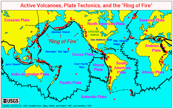
|